Comprehensive Mapping Plugin for WordPress
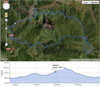
WP GPX Maps is a versatile WordPress plugin designed for travel and navigation enthusiasts. It allows users to upload GPX files to visualize tracks on an interactive map, complete with an altitude graph where applicable. The plugin supports multiple customization options, including custom colors and icons, and is available in various languages, making it accessible to a global audience. Additionally, it integrates seamlessly with NextGen Gallery, enabling users to display images associated with their tracks, enhancing the visual storytelling of their journeys.
The plugin also supports a range of analytical charts, including altitude, speed, heart rate, temperature, cadence, and grade, providing users with extensive data about their outdoor activities. Furthermore, it offers post attachments integration, allowing for easy display of images without needing NextGen Gallery. With support for multiple GPX namespaces and a welcoming translation community, WP GPX Maps stands out as a powerful tool for outdoor adventurers and WordPress users alike.